Online Maps of Bosque County
Note: Some of the links to maps below are to external websites. Because we have no control over these external websites, occasionally the links will be changed or become broken. If this occurs, let us know and we will try to correct it if the map has not been deleted from those sites.
You can scroll though the entire page or use the following links to jump down to the category of maps in which you are interested. The following abbreviations are used: TXDOT (Texas Department of Transportation), USGS (United States Geological Service), COE (United States Corps of Engineers), and GLO (Texas General Land Office).
General Maps and Geographical Information
Current TXDOT Texas County Highway Maps
Current (2019) USGS Topographical Maps with Aerial Photograpy
Historical TXDOT Texas County Highway Maps (1936, 1950, 1957, 1962, 1970, 1996)
Historical USGS Topographical Maps (1923-1924)
Historical COE Topographical Maps (1918)
Historical USGS Topographical Maps (1886-1890)
Historical GLO Original Land Survey Maps of Bosque County (1855, 1869, 1871, 1876)
Historical GLO Original Land Survey Maps of Adjacent Counties (1857-1983)
Historical GLO General Land Office Maps Related to Bosque County (1840-2016)
Historical Maps of General Interest for Bosque County (1833-1914)
General Maps and Geographical Information
Map of Bosque County - This is a general map of Bosque County showing roads, towns, and rivers with a drop-down box to locate key features. It also has layers that can be toggled on and off to show the names/location of USGS topographic maps and the school boundaries from 1932 which generallly correspond to community names.
Map of BosqueCounty (larger) - This is the same general base map shown above except it is twice as large and easier to read. However, it will require scrolling to see it all and does not contain the feature locator.
List of Geographical Features in Bosque County
Current Texas County Highway Maps (from the Texas Department of Transportation)
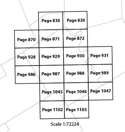
Current Topographical Maps (2019) with Aerial Photography
These are current topographic maps showing roads, towns, and rivers, and other features at a scale of 1:24000. They were produced by the United States Geological Survey in 2019. Each map is in PDF format with geospatial extensions (GeoPDF®) and contains layers of geographic data which can be turned on and off: orthoimagery (aerial photography), transportation, geographic names, topographic contours, boundaries, hydrography, structures, and woodlands. These are very accurate maps. The GeoPDF extensions allow additional functionality when the free toolbar from TerraGo is installed in Adobe Acrobat Reader. For example, latitude and longitude can be determined by holding the cursor over any point on the map.
 |
Because of the unacceptable bandwidth usage by some users, the links to these maps have been moved to a password protected directory. To obtain the userid and password, you will need to call The Bosque County Collection at 254-435-6182. Click here to access the maps. Alternately, you can use the USGS download site. |
Historical Texas County Highway Maps
These are general highway maps showing major state and county roads, streams and rivers, towns, and other landmarks. They were produced for each county by the Texas State Highway Department and successor agencies. The earliest maps did not employ aerial and satellite photography and are somewhat inaccurate. They will not sync up exactly with today's 1:24000 scale USGS maps or aerial photography and in some instances are several miles off.1936 Highway Map - Texas State Highway Department (1936). The original map is physically located in The Bosque County Collection map collection but is hosted online by the Portals to Texas History.
1950 (1941) Highway Map - Texas State Highway Department (originally prepared 1941, State highways only revised to January 1, 1950). The original map is physically located in The Bosque County Collection map collection but is hosted online by the Portals to Texas History.
1957 Highway Map - Texas State Highway Department (1957). The original map is physically located in The Bosque County Collection map collection but is hosted online by the Portals to Texas History.
1962 Highway Map - Texas State Highway Department (1962). The original map is physically located in The Bosque County Collection map collection but is hosted online by the Portals to Texas History.
1970 Highway Map - Texas Department of Highways and Public Transportation (1970). The original map is physically located in The Bosque County Collection map collection but is hosted online by the Portals to Texas History.
1996 Highway Map - Texas Department of Transportation (1986 and revised to July 1, 1996). The map is hosted online by The University of Texas Libraries.
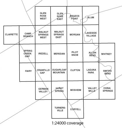
Historical Topographical Maps (1923-1924)
These are topographic maps showing roads, towns, and rivers at a scale of 1:62500. They were produced by the United States Geological Survey between 1927 and 1931 based on surveys conducted in the years shown in the index below. These maps are reasonably accurate and sync up fairly well with today's 1:24000 scale USGS maps.
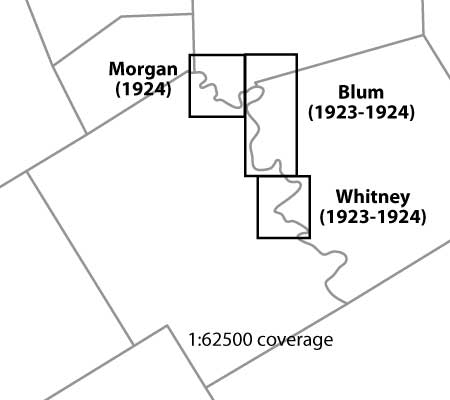 |
Download Morgan Quadrangle (5 MB PDF) Download Blum Quadrangle (6 MB PDF) Download Whitney Quadrangle (4 MB PDF) |
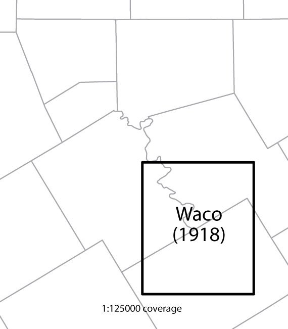
Historical COE Topographical Maps (1918)
This is a topographic map showing roads, towns, and rivers at a scale of 1:125000. It was produced by the United States Corps of Engineers in 1920 based on surveys conducted in the years shown in the index below. These maps were produced before the age of aerial and satellite photography and are somewhat inaccurate. They will not sync up exactly with today's 1:24000 scale USGS maps.
|
Download Waco Quadrangle (8 MB PDF) |
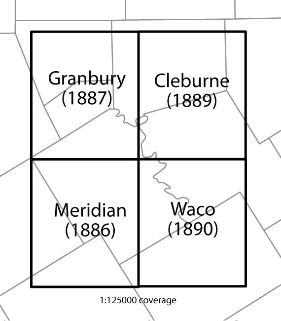
Historical Topographical Maps (1886-1890)
These are topographic maps showing roads, towns, and rivers at a scale of 1:125000. They were produced by the United States Geological Survey between 1888 and 1892 based on surveys conducted in the years shown in the index below. These maps were produced before the age of aerial and satellite photography and are somewhat inaccurate. They will not sync up exactly with today's 1:24000 scale USGS maps.
|
Download Granbury Quadrangle (8 MB PDF) Download Cleburne Quadrangle (8 MB PDF) Download Meridian Quadrangle (8 MB PDF) Download Waco Quadrangle (8 MB PDF) |
Historical Texas General Land Office Maps
These are land survey maps showing the location of original land surveys conducted during the land grant process. Under the land grant process, a prospective settler could receive a certificate for a specified amount of land under a variety of programs, each with different qualifications. Once the certificate was issued, the settler would locate available land from within the public domain. Using the certificate, the settler would have the desired land surveyed. The certificate and field notes (a written description of the survey) were then sent to the General Land Office and filed. Maps were produced for each county by draftsmen within the General Land Office using the surveys that were submitted. These maps were periodically updated to add new surveys as they were conducted. The maps are amazingly accurate considering the lack of landmarks that existed at the time. The last map in Bosque County was produced April 9, 1945.1855 Land Survey Map - Texas General Land Office (created 25 Apr 1855 by Joseph Martin). The original map is physically located at the General Land Office in Austin Texas but is hosted online by the Portals to Texas History.
1869 Land Survey Map - Texas General Land Office (created July 1869 by Joseph Martin). The original map is physically located at the General Land Office in Austin Texas but is hosted online by the Portals to Texas History.
1871 Land Survey Map - Texas General Land Office (created circa 1871 by Herman Lungkwitz). The original map is physically located at the General Land Office in Austin Texas but is hosted online by the Portals to Texas History.
1876 Land Survey Map - Texas General Land Office (created Dec 1876 by George J. Thielepape). The original map is physically located at the General Land Office in Austin Texas but is hosted online by the Portals to Texas History.
Historical Texas General Land Office Maps (adjacent counties)
These are links to land survey maps showing the location of original land surveys in adjacent counties. Some of the links are to maps on the Portal of Texas History website. Others are links to maps on the General Land Office website. If the link is to a map on the Portal of Texas History website, navigation of the map is pretty straightforward and intuitive. If the link to a map is on the General Land Office website, it is a bit more cumbersome. You will need to click the "Zoom to see detail!" link just below the map to open a new zoomable window. Then, click on the "Toggle Full Page View" icon at the far right of the -/+ zoom slider that is at the bottom of the map image. After that, you should be able to use the navigation icons at the bottom of the map.
Hill County - 1857 GLO#3672 (Portal website)
Hill County - 1862 GLO#3671 (Portal website)
Hill County - 1871 GLO#3670 (Portal website)
Hill County - 1884 GLO#82049 (GLO website) - This is a particularly useful map as it shows the locations of towns with small red dots.
Hill County - 1922 (Portal website)
Hill County - 1983 GLO#73180 (GLO website)
Historical General Land Office Maps Related to Bosque County
These following links and PDFs are hosted by the Texas General Land Office. Paper copies are available for purchase from the General Land Office.
Map No. |
Map Link |
Year |
Description |
3312 |
1855 |
Bosque County Map of Original Land Surveys | |
3313 |
1869 |
Bosque County Map of Original Land Surveys | |
3315 |
ca1871 |
Bosque County Map of Original Land Surveys | |
1519 |
1876 |
Bosque County Map of Original Land Surveys | |
420 |
1879 |
Bosque County Map of Original Land Surveys | |
88910 |
1879 |
Bosque County Map of Original Land Surveys | |
7814 |
1890 |
Bosque County Map of Original Land Surveys | |
4888 |
1890 |
Bosque County Map of Original Land Surveys | |
77215 |
1945 |
Bosque County Map of Original Land Surveys | |
1783 |
1945 |
Bosque County Map of Original Land Surveys | |
73083 |
1945 |
Bosque County Map of Original Land Surveys | |
50672 |
No Date |
Bosque County Boundary File 1 | |
50689 |
No Date |
Bosque County Boundary File 11 | |
8452 |
1978 |
Bosque County Rolled Sketch 1 | |
5160 |
1984 |
Bosque County Rolled Sketch 2 | |
89015 |
No Date |
Bosque County Rolled Sketch 3 | |
14740 |
1847 |
Bosque County Sketch File 02 | |
14742 |
1848 |
Bosque County Sketch File 03 | |
14744 |
1854 |
Bosque County Sketch File 04 | |
14746 |
1847 |
Bosque County Sketch File 05 | |
14748 |
1851 |
Bosque County Sketch File 06 | |
14750 |
1852 |
Bosque County Sketch File 07 | |
14752 |
1858 |
Bosque County Sketch File 08 | |
14754 |
1859 |
Bosque County Sketch File 09 | |
14757 |
1860 |
Bosque County Sketch File 10 | |
14759 |
1863 |
Bosque County Sketch File 11 | |
14761 |
1863 |
Bosque County Sketch File 12 | |
14763 |
1863 |
Bosque County Sketch File 14 | |
14774 |
1863 |
Bosque County Sketch File 15 | |
14781 |
No Date |
Bosque County Sketch File 16 | |
14788 |
1863 |
Bosque County Sketch File 17 | |
14792 |
1863 |
Bosque County Sketch File 18 | |
14794 |
1863 |
Bosque County Sketch File 19 | |
14796 |
1863 |
Bosque County Sketch File 20 | |
14798 |
No Date |
Bosque County Sketch File 21 | |
14804 |
1863 |
Bosque County Sketch File 22 | |
14806 |
1863 |
Bosque County Sketch File 23 | |
14809 |
No Date |
Bosque County Sketch File 25 | |
14811 |
1868 |
Bosque County Sketch File 26 | |
10937 |
No Date |
Bosque County Sketch File 27 | |
14813 |
1888 |
Bosque County Sketch File 28 | |
14816 |
1863 |
Bosque County Sketch File 29 | |
14819 |
No Date |
Bosque County Sketch File 30 | |
14822 |
1854 |
Bosque County Sketch File 30a | |
14826 |
1854 |
Bosque County Sketch File 30b | |
14830 |
1867 |
Bosque County Sketch File 31 | |
10938 |
1944 |
Bosque County Sketch File 32 | |
10939 |
1895 |
Bosque County Sketch File 33 | |
78486 |
1856 |
Bosque County Sketch File 34 | |
67434 |
No Date |
Bosque County Working Sketch 01 | |
67435 |
No Date |
Bosque County Working Sketch 02 | |
78192 |
1901 |
Bosque County Working Sketch 03 | |
67437 |
1901 |
Bosque County Working Sketch 04 | |
67438 |
1935 |
Bosque County Working Sketch 05 | |
67439 |
1939 |
Bosque County Working Sketch 06 | |
67440 |
1942 |
Bosque County Working Sketch 07 | |
67441 |
1942 |
Bosque County Working Sketch 08 | |
67442 |
1943 |
Bosque County Working Sketch 09 | |
67443 |
1944 |
Bosque County Working Sketch 10 | |
67444 |
1952 |
Bosque County Working Sketch 11 | |
67445 |
1957 |
Bosque County Working Sketch 12 | |
67446 |
1957 |
Bosque County Working Sketch 13 | |
67447 |
1962 |
Bosque County Working Sketch 14 | |
67448 |
1963 |
Bosque County Working Sketch 15 | |
67449 |
1974 |
Bosque County Working Sketch 16 | |
67450 |
1975 |
Bosque County Working Sketch 17 | |
67451 |
1976 |
Bosque County Working Sketch 18 | |
67452 |
1976 |
Bosque County Working Sketch 19 | |
67453 |
1976 |
Bosque County Working Sketch 20 | |
67454 |
1984 |
Bosque County Working Sketch 21 | |
67455 |
1984 |
Bosque County Working Sketch 22 | |
67456 |
1984 |
Bosque County Working Sketch 23 | |
67458 |
1994 |
Bosque County Working Sketch 24 | |
67457 |
1994 |
Bosque County Working Sketch 24 | |
67459 |
1994 |
Bosque County Working Sketch 25 | |
67460 |
1995 |
Bosque County Working Sketch 26 | |
85241 |
2006 |
Bosque County Working Sketch 27 | |
88997 |
2009 |
Bosque County Working Sketch 29 | |
89066 |
2009 |
Bosque County Working Sketch 30 | |
89277 |
2010 |
Bosque County Working Sketch 31 | |
93687 |
2014 |
Bosque County Working Sketch 32 | |
93980 |
2016 |
Bosque County Working Sketch 33 | |
76469 |
1945 |
Bosque County Working Sketch Graphic Index | |
79022 |
1940 |
General Highway Map, Bosque County, Texas | |
79378 |
1961 |
General Highway Map, Bosque County, Texas | |
79379 |
1961 |
General Highway Map. Detail of Cities of Towns in Bosque County, Texas | |
76047 |
No Date |
Grant of Miguel Rabago | |
146 |
1841 |
Map of Brazos & Bosque Surveys | |
69755 |
1847 |
Neil's Creek of North Bosque | |
65263 |
1925 |
Water-Shed of the Brazos River | |
64564 |
1945 |
[GC&SF RR Through Bosque County from McLennan Co. and E. to Hill Co. Station M. P. 259 to M. P. 297] | |
64563 |
1945 |
[GC&SF RR Through Bosque County from McLennan Co. and E. to Hill Co. Station M. P. 259 to M. P. 297] | |
238 |
1845 |
[Surveys along Bosque and Hog Creek] | |
69759 |
1846 |
[Surveys along Childress Creek in Bosque County] | |
242 |
1846 |
[Surveys along Meridian Creek] | |
69761 |
1846 |
[Surveys along Neils and Turkey Creeks] | |
236 |
1846 |
[Surveys along the Bosque River] | |
71 |
[1840] |
[Surveys along the Brazos River] | |
3 |
1847 |
[Surveys in Milam District between the Bosque and Brazos Rivers] | |
231 |
1846 |
[Surveys in the Milam District along the Brazos River, North Bosque River, West Bosque River and Cow Bayou] | |
3170 |
1846 |
[Surveys in the Milam District on Bosque River and Spring Creek] | |
3171 |
1846 |
[Surveys in the Milam District on Coryell Creek and the Bosque River] |
Historical Maps of General Interest for Bosque County
These are links to historical maps of general interest for persons researching Bosque County. They may include areas outside of Bosque County but do include the area of Bosque County in their coverage.
1833 Map of Coahuila and Texas (1.2 MB PDF)
1841 Route of First Santa Fe Expedition (0.7 MB PDF)
1849 Reconnoissance by Lieutenant W.H.C. Whiting (1.9 MB PDF)
1851 J. De Cordova's State of Texas (3.7 MB PDF)
1852 Texas Map Showing Principal Forts (0.9 MB PDF)
1874 A. R. Roessler's Latest Map of Texas (11.3 MB PDF)
1893 Railroad and County Map of Texas (2.7 MB PDF)
1901 Railroad and County Map of Texas (2.1 MB PDF)
1903 Railroad and County Map of Texas (3.0 MB PDF)
1908 Railroad and County Map of Texas (6.6 MB PDF)
1914 Railroad and County Map of Texas (8.1 MB PDF)
